This content was created by Weiting Guo. The last update was by Kate McDonald.
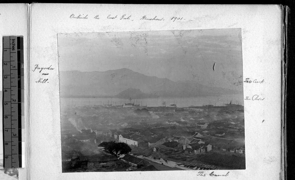
"View of the city, Wenzhou, Zhejiang, China, 1901"
1 media/Yale Wenchow_thumb.jpg 2021-08-23T15:43:26-04:00 Weiting Guo 08b125beef921c47ad1de3c337b8d14abd2713ab 35 4 "View of the city, Wenzhou, Zhejiang, China, 1901." The original is held by the Yale Divinity School Library, Yale University, in Special Collections, Robert Grierson Papers. Many thanks to Yale Divinity School Library. Credit line: "Special Collections, Yale Divinity School Library.” plain 2021-09-02T11:06:53-04:00 "View of the city, Wenzhou, Zhejiang, China, 1901." Special Collections, Yale Divinity School Library. Asia (continent), Chekiang (region) "Outside the East Gate, Wenchow, 1901." In margins: "Pagoda on Hill."; "The Canal"; "The River"; "The Creek." [now Wenzhou] A wide shot of the city, showing various buildings and the river and hills in the background Yale University. Divinity School Yale Divinity School Library. Used with permission. WG-0051 IMP-YDS-RG008-257-0002-0022.tiff View of the city, Wenzhou, Zhejiang, China, 1901 general views (aat), Urban areas (unesco) International Mission Photograph IMP-YDS-RG008-257-0002-0022.tiff Kate McDonald 306bb1134bc892ab2ada669bed7aecb100ef7d5fThis page is referenced by:
-
1
2019-11-18T17:25:07-05:00
Building on Water
19
plain
5336
2021-08-23T15:51:42-04:00
27.9994, 120.6668
Wenzhou
1931
Weiting Guo
Soothill, Lucy
Soothill, William
Our enforced isolation on the River's Heart had one advantage. It gave us better opportunities to explore the neighbourhood than we ever had again. The City-of-the-South is considered to be one of the most picturesque of Chinese cities, and I have heard it grandiloquently called the Venice of China. We certainly made the most of its river, charming scenery, and encircling hills, thereby provoking sarcastic comments from the Commissioner. "You cannot eat hills. A club would be more satisfying," he said.
In 1931, Lucy Soothill (1857–1931) made this vivid comment in her bibliographical book, A Passport to China. She and her husband, noted Sinologist and missionary William Edward Soothill (1861–1935), lived in Wenzhou for nearly 25 years (1884–1907; William arrived in 1881). They once lived in the “River's Heart” — an island in the middle of the river that housed the British consulate during their stay. They also established many churches and used them as major sites for their mission. After heading to North China for another two-decade journey, the couple still reminisced about this beautiful city. They began calling it “The City-of-the-South,” as this town had been so special in their long trip across China.
To Lucy, this “[one] among the cleanest of Chinese cities” had brought them incredible memories. Rivers and canals scattered across the city. Bridges and boats connected the communities, and people used waterways as often as land routes. While these appeared to be exotic to Lucy, they also left her with unforgettable experiences. Lucy greatly enjoyed the convenience of canals and small boats. She noted how canals in Wenzhou differed from the English rivers she used to live beside:
The waterways of South China are wonderful. Some of the canals are as wide as our English rivers, run long distances, and are often beautiful. We sat in the bottom of the little boat, our bedding making excellent back-rests, being so arranged by our youthful attendant, the Bright One. The canal carried us "past twenty towns and half a hundred bridges." At one o'clock we stopped outside the temple of The Narrow Gate, where we ate our lunch and obtained boiling water for our coffee… At three in the afternoon we reached the City-of-Clear-Music-Ngoh-ts'ing… There were no railways, cars, cabs, horses, or carts; no mills, gas, or electric light. Nothing but the long rows of one-storeyed dwellings, plenty of empty spaces, and several fine canals.
Apparently, Lucy was quite impressed by how vastly this city was “built on” the water. In the following parts of this module, I offer examples of these incidents during the late 19th century and the early 20th century, to elaborate on what this water town was like during the turn of the century and how it went through social and political transformations throughout this period.
.jpg)