Sacred Geographies of Urban Colonial Taiwan: Jilong's Geography in Transformation
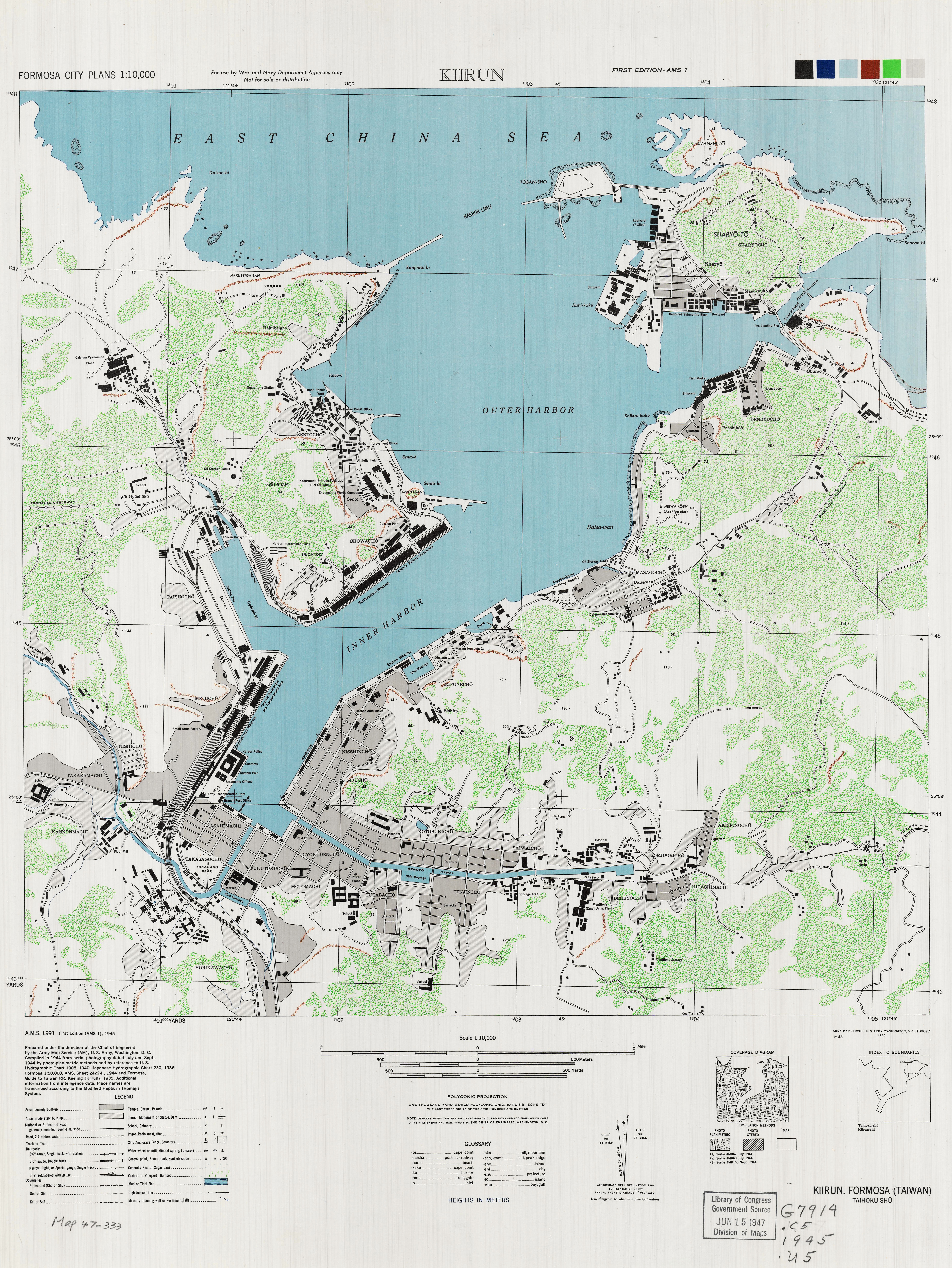
Colonial regimes, almost by definition, engage in the transformation of the spaces into which they insert themselves. This practice, however, is not unidirectional or simply imposed upon the colonial terrain. It is a contested process in which all actors advance their territorial visions through methods that include asserting ownership, restructuring the physical geography, and passive and active forms of resistance. Jilong (Keelung) became a site for processes of de/reterritorialization under Japanese colonial rule when it emerged, briefly, as the location of the first headquarters of the Taiwan Government-General in June 1895. Those processes intensified when Jilong served as the primary port of entry for most of the fifty years of Japanese rule. The town, its harbor, its terrain, its people, all of these facets left Japanese control in 1945 in radically altered conditions. The most obvious aspects of these changes—the different physical and urban topographies visible in these two historic maps—is not evidence of the successes of Japanese colonial rule. Nor does the quantity and distribution of temples during the 1930s in a third map demonstrate a permanent remapping of the sacred or physical terrains. A spatial exploration of the sacred geographies within Jilong reveals a very different outcome: the construction and assertion of an ethnic Taiwanese identity through temples and their associated festivals, in opposition to Japanese efforts to reconsecrate Taiwan through Shintō and missionary Japanese Buddhism. Many observers of Taiwan have examined Taiwanese nationalism, mostly in an effort to understand the history and current features of Taiwan’s independence movement. However, the competition over religious institutions and activities that took place between 1895 and 1945 produced a different form of Taiwanese identity. Briefly put, consistent opposition to fifty years of Japanese assimilation policies promoted the construction of Taiwanese ethnicity, but not necessarily an independence-minded nationalism.
The Taiwanese, or rather, the people who became Taiwanese through their participation in the definition of both physical and imagined geography, constituted the largest portion of the population in Jilong. These people, called “islanders” (hontōjin or bendaoren 本島人) by the Japanese who colonized Taiwan, had genealogical roots in Southeastern China and had settled in the island during the two centuries of Qing rule over the island (1684-1895). They came from different homelands, or “native places,” spoke different languages, and fought with each other over land and resources. Even though they were outsiders by comparison to the indigenous peoples who had been the main human inhabitants of Taiwan before these Southeastern Chinese arrived, by the advent of Japan’s rule, most had gone through a process of localization or nativization (bentuhua 本土化). From the perspective of the other main ethnic group living in Jilong, the Japanese settlers, the Taiwanese were natives who needed to be transformed and uplifted through Japanese influence. Both the islander/Taiwanese locals and the Japanese settlers asserted control over physical and sacred terrain, often in competition with each other. (When I use the term “native,” I refer to the islanders, not to the indigenous peoples of Taiwan. However, indigenous groups also contested with Japanese over sacred geography, including well after the end of Japanese rule in Taiwan, such as when a group went to Yasukuni Shrine in 1979 and demanded the return of the spirits of their ancestors who had been enshrined there for service to the Japanese Empire in World War Two (Ching, Becoming “Japanese”).)
In narrating this history, I demonstrate that these contested territorializing projects created space and place in colonial Jilong. The projects themselves involved self-conscious efforts to define the physical terrain through modern cartography, state policy, and social activity of a largely religious nature. I highlight the first of these in particular by using a number of historic maps, most of them created by the Japanese colonial government, which present a flat, totalizing vision of space in which states attempt to control places through their description and delineation. Nevertheless, modified versions of these maps highlight the points of intersection between sacred and profane, between physical and imaginative geographies—that is, the temples and the territorial cults of their principal deities. In using them, I bring out what the state's maps hide: the people who created place by applying meaning to space through their everyday relationships. Also, I rely mostly on a Japanese map of the city to visually emphasize that Taiwanese used their religious institutions and practices to oppose Japanese efforts to control and transform the colony. Points on a map do not indicate absolute or natural linkage between a place and an identity. Rather, they represent the results of the fluid interactions among key actors: elites from different ethnic groups; between elites and the colonial state; and between elites, non-elites, and the deities that they worshiped. These actors contributed to the construction, reinforcement, and transgression of a set of porous boundaries between Taiwanese and Japanese identities and their affiliated social groups; between sacred and profane; and between physical and imaginative geography.
The diagram below shows the module's structure. Click on a node to reveal the pathways, pages, or media objects to which is connects.
The module contains six pathways. The first, “Sacred Geography: Definitions,” provides an important conceptual entryway, and I encourage readers to explore its pages before proceeding into the the main body of the module, which follows pathways that address the Taiwanese and Japanese efforts to define and control the sacred and profane. Both of these threads link to a fourth, on the competing festivals that highlighted the efforts to claim and occupy both physical and imaginative geography; and to a fifth that depicts the failure of Japanese efforts to make Jilong a purely Japanese sacred space. The module ends with a brief examination of the post-1945 florescence of religion as a key marker of Taiwanese identity. Links to explanations of key concepts are scattered throughout the module, so that readers will better understand how islanders/Taiwanese and Japanese created space and place in urban colonial Taiwan.
Click here for a list of references for this module, which is also available from the module's Conclusion page.
Note: “Sacred Geographies of Urban Colonial Taiwan: Jilong’s Geography in Transformation” is based on material that appeared in sections of Evan N. Dawley, Becoming Taiwanese: Ethnogenesis in a Colonial City, 1880s-1950s (Cambridge, MA: Harvard University Asia Center, 2019). The text of this module cannot be reproduced, shared, altered, or exploited commercially in any way without the permission of the Harvard University Asia Center. It is copyrighted material and not subject to the allowances permitted by the CC-BY-NC-ND license.