Mapping Production
Each collection, boxed or unboxed, embodied a network of production and distribution. If unpacked, it speaks of local labor, local conditions for production, and transportation routes. Where did all the goods that Mitsukoshi sold come from? These stories are generally left out of the usual accounts of this retailer. We might begin by asking who made Mitsukoshi's foundational commodity, textiles? Janet Hunter's article, "Japanese Women at Work, 1880-1920," is an excellent starting place for learning more.
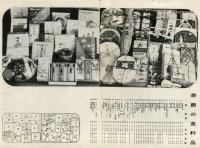
Below we have a gift box of food items curated for the winter season, each item carefully labeled by type. If we think of it in terms of production rather than consumption, we can begin to map out points in an Osaka-centered network in the map above. Would it look different if the gift box was offered by a branch of Mitsukoshi in Tokyo? If you look closely, you will find that the Mitsukoshi brand was on several items. What kind of arrangement did this represent? Was it just a label, or was Mitsukoshi more directly involved in maritime and agricultural production, as it was in manufacture? There are many questions to be answered when we try to reconstruct the production side of Mitsukoshi.
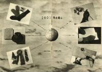
Below is a "map" that hints at production and circulation lines on a much broader scale. While the goods themselves were rather ordinary, the graphic composition implied that such items flowed to a Japanese center from all over the world. Was this a map-like gesture to claim dominance? Could one draw such a map for a non-imperialist power? More broadly, how might this and other product maps be used to discuss the distribution of power across regions, nations, and the world, and how these relations might shift over time?