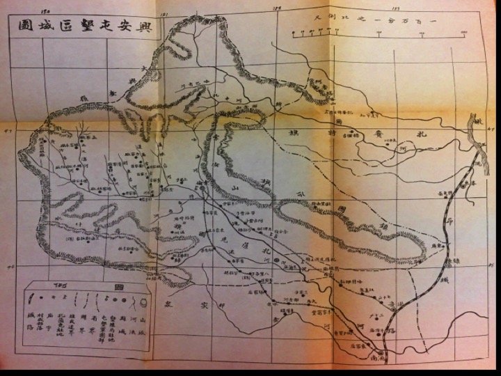
Xing An: A Contested Borderland
What defines a place? What makes for a borderland? The Xing An (Jp. Shing An) Military Land Reclamation Zone (Ch. 興安屯墾區) stretched across an area that on a map looks blank, a wholly unremarkable zone marooned on the Asian mainland. Yet in the 1920s and 1930s, this piece of land was a contested prize for China, the Soviet Union, and Japan and the subject of hundreds of pages of reports and surveys commissioned by the Public Security Bureau of the Three Northeastern Provinces. How and why this came about opens a window on the way science, social science, and empire played out on the ground in Asia. Xing An reflected how the spatialities of empire and nation overlapped in complex ways as both Japanese officials bent on expanding the empire and nationalist Chinese officers who sought to reinforce border defenses resorted to the language of science and modernization to define a blank space on the map.
This module examines Xing An using Chinese reports on the progress of the military settlement of the area. The module follows two pathways. One path, "The Making of a Contested Territory," focuses specifically on Xing An and the various ways Chinese officers in creating a nation and boundary-making project inscribed their nationalist ambitions onto the map. A second pathway, "The Science of Empire," opens up connections to global discussions about empire, state building, and the science of frontier settlement and development. As the Japanese empire expanded, it encountered various points of resistance. Xing An is one place where the Chinese countered Japan with its own colonization experiment; where contested ideas about empire intersected with the nation.