Mapping Invasion: Biological Warfare During the First Indochina War
This module examines various responses to the threat of biological warfare in Vietnamese territory in the early 1950s. This type of warfare involved the intentional use of microbes, and the living and non-living vectors that carry them, to weaken or kill humans considered enemies. In the context of total war, biological warfare was also directed at the animals and plants that helped sustain those people.
During the Cold War, what was a biological invasion and how it would happen were questions that caused anxiety and fear. This fear of invasion has been explored in the US context but less so for other societies, especially in the “Third World,” which was the site of so many types of invasions. Traditional understandings of invasions, or unwanted border crossings, in Vietnamese society have revolved around humans including Mongols, Chinese, and French armies. But biological warfare techniques developed in the twentieth century meant that non-human nature, and the environment itself, could become an invasive threat. Vietnamese medical doctors and cadre became concerned about insidious invasions that would go undetected until after it was too late to resist them and they had to grapple with several questions: What were the geographies of invasion? At what scale could they happen? What would an invasion look like? How could an invasion be differentiated from “natural” processes? Who, and what, would invade? How, in short, could invasions be mapped? And then, perhaps most importantly, how could these invasions be stopped?
Focusing on Vietnamese perspectives on biological warfare reveals that mapping and mobilities (of the geobody and body) were key to this warfare and responses to it. These two processes may seem to exist in tension: maps define and solidify, while mobility destabilizes and makes “all that is solid melts into air.” Yet, the two processes depend on each other. On the one hand, maps cannot be created without movement and exploration. There is the physical movement of the explorer and the material and symbolic flows that happen in knowledge networks. Airplanes have helped this mapping. On the other hand, understanding, and therefore engaging in, movement is very difficult if not impossible without some kind of map. These maps can be official, state created maps or they can be unofficial and personal, from individual mental maps to communal songlines to airplane routes. So mapping and movement are two complementary, intertwined processes.
Even if biological warfare during the First Indochina War did not happen, this period shows a mix of old and new maps being used to understand new forms of microbial, human, and machine movement. Vietnamese intellectuals and political leaders thought in terms of existing Sinosphere maps that politically, intellectually, and culturally connected China to Korea and Vietnam. Vietnamese leaders turned to these countries for relevant experience and to learn from them. Reoriented by colonial experience, Vietnamese intellectuals also placed themselves in maps of France and its colonies. Newer maps of the communist world both reinforced Sinosphere maps and placed Vietnam at the center of newer political geographies of connection. Mapping was also a way to bound very local space. Thus, Vietnamese leaders mapped emotional geographies through surveys of countryside, human mobility, and the possibilities and dangers it might bring. Finally, from a Vietnamese perspective, airplanes were a new source of mobility, and terror. During the colonial era, airplanes were used to map Indochina and to rain bombs down on those protesting colonial injustice. During the 1940s, airplanes, and other technologies, potentially transported deadly microbes. In fact, microbes and airplanes resulted in compounding mobilities—mobilities whose velocity and outcomes were unpredictable and threatening.
Thus, this module argues that Vietnamese responses to environmental warfare were inherently spatial. They depended, for example, on information gathered from sources spread out in space, from conferences held in Beijing to surveys of farmers in the Red River Delta. Moreover, this intellectual geography overlapped, and existed in tension, with the political geography of civilizations and nation-states, the emotional geography of care and localities, and the geographies of disease linking microbes and airplanes.
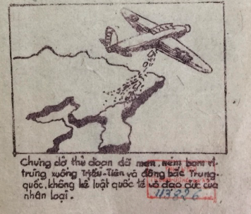
In order to explore the mapping and mobilities of invasions, this module is divided into three pathways, each of which explores a different theme in biological warfare. Path 1 encourages users to explore the charges of American biological warfare in North Korea and China beginning during the Korean War. It does so by examining Chinese posters produced during the Korean War, notes from an international conference about US biological warfare, and a pamphlet produced by medical doctors working with the Việt Minh, the anti-colonial forces led by Ho Chi Minh. This path provides background to the development of biological weapons and shows how germ warfare in Northeast Asia was viewed in Vietnam. Path 2 encourages users to explore biological warfare in the Red River Delta during the First Indochina War. Drawing from Việt Minh reports about rural Red River Delta from 1952 to 1954, this path traces the steps that the Việt Minh took to produce knowledge about biological warfare. It also provides a map with suspected instances of biological weapons use in northern Vietnam. Path 3 encourages users to explore the experience of biological warfare and the efforts to counter it. This path looks at the life and work of Tôn Thất Tùng, one of the most famous Vietnamese medical doctors, and the part he played in attempts to deal with the threats of biological warfare. Finally, it reviews the attempts at a Vietnamese Patriotic Hygiene Movement.
In addition to the written description of this module above, you can access this module visually through the roadmap to the right. You can either follow the paths linearly by going from path one to two to three, or focus on particular topics and tags using the Tag Map, the Geotagged Map, and the Grid Visualization.