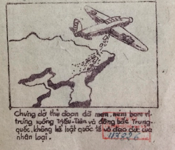
This module analyzes Vietnamese responses to the French military's possible use of biological warfare during the First Indochina War (1946-1954). Beginning in 1952, the Việt Minh, the anti-colonial popular front forces led by Ho Chi Minh, collected reports of French airplanes releasing powders, worm-infested leaflets, and other strange substances over Việt Minh-controlled territory in and around the Red River Delta. These reports assumed that the strange substances were biological weapons, including insects and microbes meant either to sicken or kill humans directly or to infect plants and animals and threaten the Vietnamese food supply. Such reports lasted until at least the battle of Điện Biên Phủ in 1954.
This module argues that Vietnamese responses to biological warfare were inherently spatial. They depended, for example, on mapping information gathered from dispersed sources, from conferences held in China to surveys of farmers in the Red River Delta. Moreover, this intellectual geography overlapped, and existed in tension, with a political geography of civilizations, regions, and nation-states, an emotional geography of fear, and a medical geography that linked airplanes, environments, microbes, and humans. Unpacking the (non) event of biological warfare shows, in turn, how responses to biological weapons had complicated effects on Vietnamese spatial imaginaries. From a Vietnamese perspective, germ warfare helped place northern Vietnam in reconfigured Sinosphere and borderland relationships and created newer nationalist and revolutionary worlds. In other words, this period shows a mix of old and new maps being used to understand new hybrid environments of microbial, human, and machine movement.
To make maps useful for combatting biological warfare, the Việt Minh had to understand conditions in local places at specific moments. Moving from generalized knowledge about the Sinosphere to specific knowledge about places in the Red River Delta took hard work. This module seeks to trace and, in a limited way, reproduce the labor needed to map the mobilities and immobilities of invasion. In other words, the structure of this module mimics the movement from general to specific, and old to new, and the intellectual and physical labor needed to make such a move. Such a structure encourages users to reflect on how historical actors moved between scales that were different in quantity and in quality, shifting between different geographic scales—global, regional, national, and local—and different types of maps—civilizational, emotional, and biogeographical. In other words, this module examines what certain Vietnamese thought about biological warfare and to explain what those actors thought with and how these structures changed over time.
This module is divided into three pathways, each of which explores a different theme in biological warfare. Path A is called “Learning from the Korean War.” It encourages users to explores communist charges of biological warfare in North Korea and northeast China leveled against the United States military. It examines notes from a Vietnamese delegation to an international conference about biological warfare along with Chinese posters produced as part of a patriotic hygiene movement. A side path shows how northern Vietnam has been incorporated into various spatial imaginaries. Path B is called “Surveying Northern Vietnam.” It encourages users to explore biological warfare in northern Vietnam during the First Indochina War. Drawing from reports of the Committee to Prevent Germs, this path traces the steps that the Việt Minh took to produce knowledge about biological warfare. A side path explores the life of one of the committee's leaders, the famous Vietnamese medical doctor Tôn Thất Tùng. Finally, this path offers a Google map of a few suspected incidents of biological weapons use drawn from the committee's work and other Việt Minh reports. Path C is called “Preparing for Biological Warfare.” Such efforts included included producing and distributing a pamphlet meant to popularize knowledge about the history of American and Japanese use of biological weapons. This pamphlet sought to mobilize domestic Vietnamese audiences to fight. It aimed as well to show international audiences the Vietnamese connections to the communist revolutions that had taken place in China and Korea. Finally, the Việt Minh organized a Vietnamese Patriotic Hygiene Movement modeled on the Chinese Patriotic Hygiene Movement.
Click here for a list of references for this module, which is also available from the module's Conclusion page.