Bodies and Structures 2.0 allows us as scholars and students to take ownership of our maps. As we wrote in an earlier essay, “The map is not a given. We map, and in doing so we produce knowledge. But we also produce fictions, and elisions. Ownership entails the responsibility to map in ways that align with the ethics of our scholarship” (Ambaras et al. 2019).
Owning our maps leads to ontological and epistemological “so whats” and “takeaways.” The first contribution of Bodies and Structures 2.0 is ontological. The critical geographic and spatial humanistic theory that helped us to frame this project has been in development for over forty years. We are, in other words, not the first to recognize the need for multivocal mapping, for liberating the map, and for provincializing cartographic rationalities (Corrigan 2015; Pearson and Shanks 2014; Pickles 2012; Winichakul 1997; Certeau 1984). What Bodies and Structures 2.0 offers is the visceral experience of multivocal mapping—the ability to encounter and analyze historical experiences in multiple spatialities, with frameworks provided by our editorial collective and / or that readers supply via the Lenses tool. In the words of John Corrigan, the site’s collaborative design “fosters intersections in research” and “complicate[s] the stories we can tell.” It provides students, scholars, and teachers a way of approaching the past that “leverages the open-endedness and the polyvocality of spatial humanities and the often surprising insights derived from that enterprise to create narratives that are more inclusive, that bridge gaps, that challenge familiar categories of space and time as historical constructs that privilege some voices and marginalize others” (Corrigan 2021). Bodies and Structures 2.0 uses collaboration and digital methods to demonstrate not just the rich possibilities that multivocal mapping offers, but also the essential need to write and think in ways that presume the multivocality of space and place.
Essential Situatedness: From Critique to Structure
Bodies and Structures 2.0 invites readers to stand certain in the essential situatedness of knowledge and experience about space and place. It asks scholars to attend not to the question of “what” is space and place, but rather “whose space” and “on what terms?” It precludes metonymies of scale—allowing a history of one province, one individual, or one culture to stand in for the whole. Instead, it posits a deep map of modern East Asia that both spans the entire globe and renders such a universalized spatiality impossible.
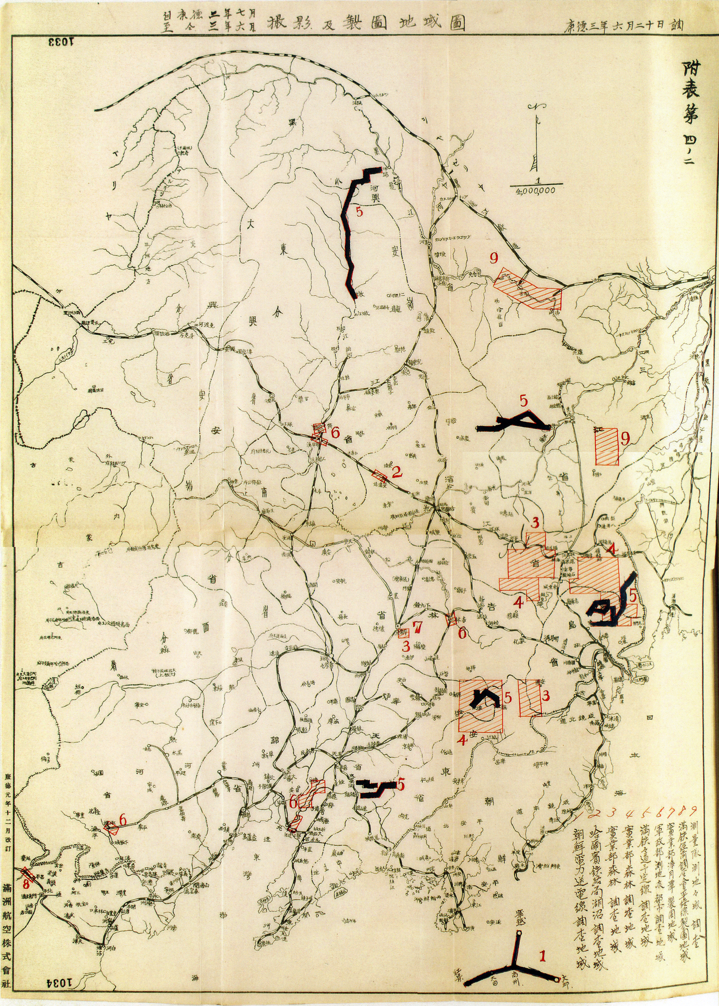
As in the case of our critiques of cartographic rationality, we are not the first to suggest that the borders of “Asia” or “modern East Asia” are porous, that the spatial experience of Asia is always emergent, or that the meaning ascribed to the regional framework has more to do with geopolitics than lived histories (see, e.g., Tagliacozzo, Siu, and Perdue 2015a, 2015b, and 2019; Ho 2017; Duara 2010; Lewis and Wigen 1997). Bodies and Structures provides a research environment in which these insights are the foundation, rather than the critique. For example, the site does not gather its many cartographic images under a tag called “Maps.” Instead, the site uses the tag “Mapping” to place cartographic representations and regionalizations within a melange of ways in which historical actors have made spatial differences meaningful. Bodies and Structures conducts a mapping operation that is less about identifying parcels of absolute space or plotting specific steps in an itinerary, and more about cognitively reframing our perception of the rhetorics and technologies used to produce modern East Asia as a certain kind of space amenable to specific operations of power. Mapping includes many examples of historical cartography (e.g., “Cartographies of Northern Vietnam”; “Aerial Innovations in Mapping”; “Surveying Empire”; “Capital Punishment”). But it also includes the practice of ascribing higher artistic value to the works of artists in Japan's inner territories in contrast to those of “settler-artists” working in colonized territories (“Model Works”), the construction of the Lingquan Temple in Taiwan as a site of fusion between Chinese and Japanese Buddhism (“The Lingquan Temple: Taiwanese Buddhism”), and a Chinese lithograph that visualizes the future and traces its passage from Paris to London to Shanghai (“The Trottoir Roulant”). We know that the cartographic map occludes in order to illuminate. “Mapping” illuminates and then asks what else we need to include.
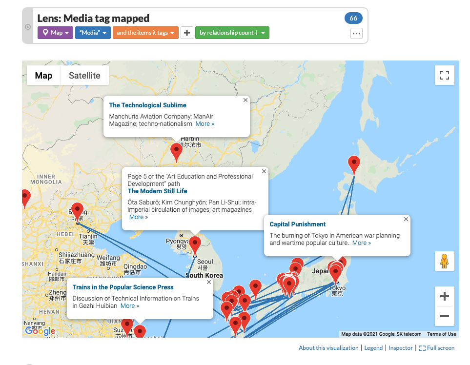
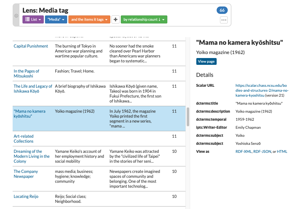
Through its visualizations, tags, and opportunities for nonlinear reading, Bodies and Structures enables users to read across places and, in so doing, shift from thinking about map as a noun to thinking about mapping as always already a verb. In a similar fashion, Bodies and Structures 2.0 approaches “scale” as an act of situated knowledge making and human action rather than a matter of absolute geometry. By putting the tag “media” onto a cartographic map (via the Lenses tool), for example, we can consider how representations and imaginative geographies operating in a given locality might be connected to others. Rendering the same tag relationships as a list affords a different possibility for visualizing the site’s contents, in this case suggesting the different ways and scales at which spatial processes were constituted and experienced: e.g., from the air, on the printed page, and in gendered, embodied movements that included the consumption and manipulation of new material objects and technologies.
The coexistence or simultaneity of different ways of constituting and experiencing space and time underscores the need to approach scale critically when deep-mapping modern East Asian history. Used without reflecting on the rationality that produces it, scale naturalizes particular spatial structures (e.g., local, regional, national, and international; or micro, meso, and macro) as space itself (see, e.g., Howitt 1998). Multiple scales—if they are constituted within the same, unspoken rationality—do not necessarily produce a critical spatial history. In contrast, Bodies and Structures 2.0 uses the tag “Rationalities” to highlight the logics of space and time that distinguish one spatiality from another. Though they exist in the same time and place, the spatio-temporality of a spatial structure governed by a “vital rationality,” for example, differs significantly from one governed by a “territorial rationality.” In the former, the time that a given living being can survive determines distance, including the meaning of adjectives such as “near” and “far.” In the latter, the ability of the bureaucratic and social structures of the state to demarcate and manage territorial boundaries determines the difference between “here” and “there” or “domestic” and “foreign.” Significantly, the difference between rationalities is not necessarily one that can be defined through comparisons within categories. Instead, Rationalities shows that different spatial logics define space and time by prioritizing completely different categories.
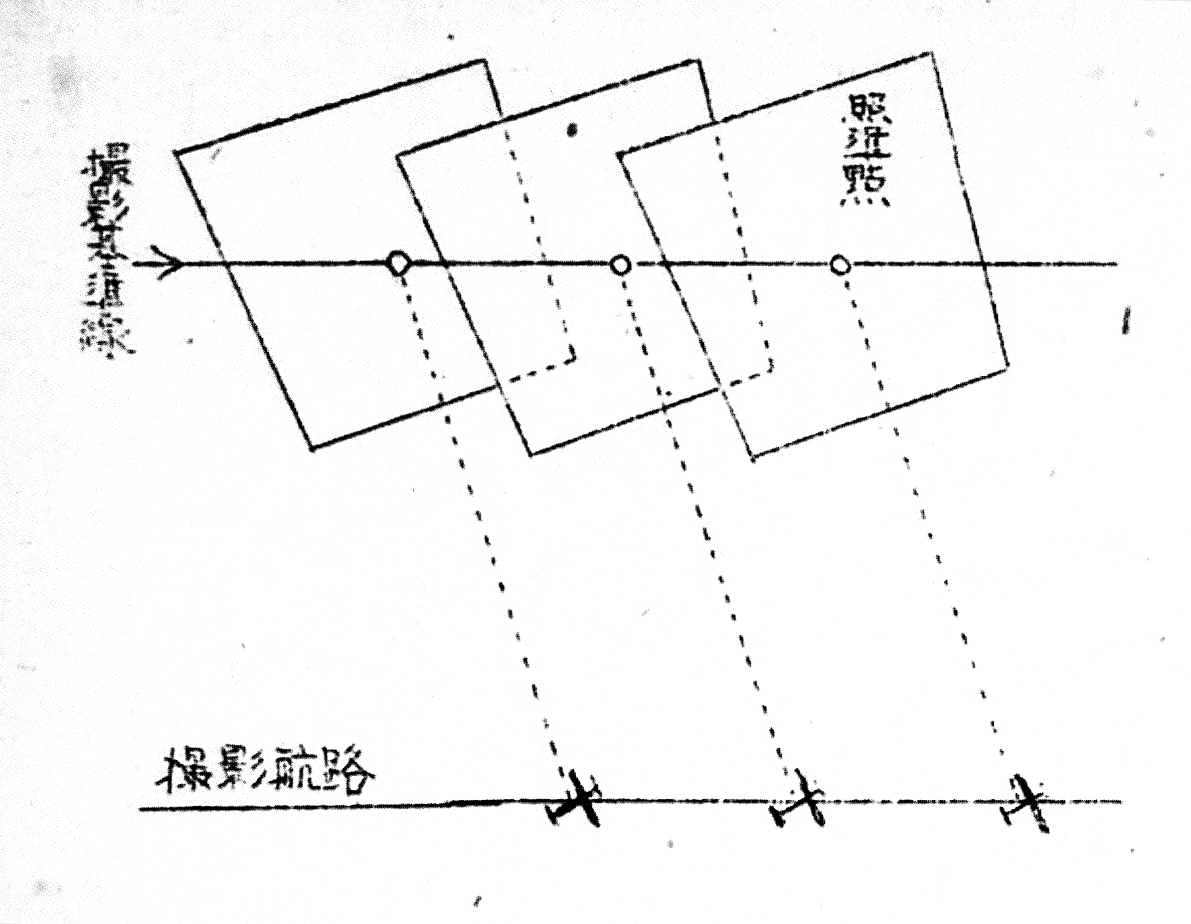
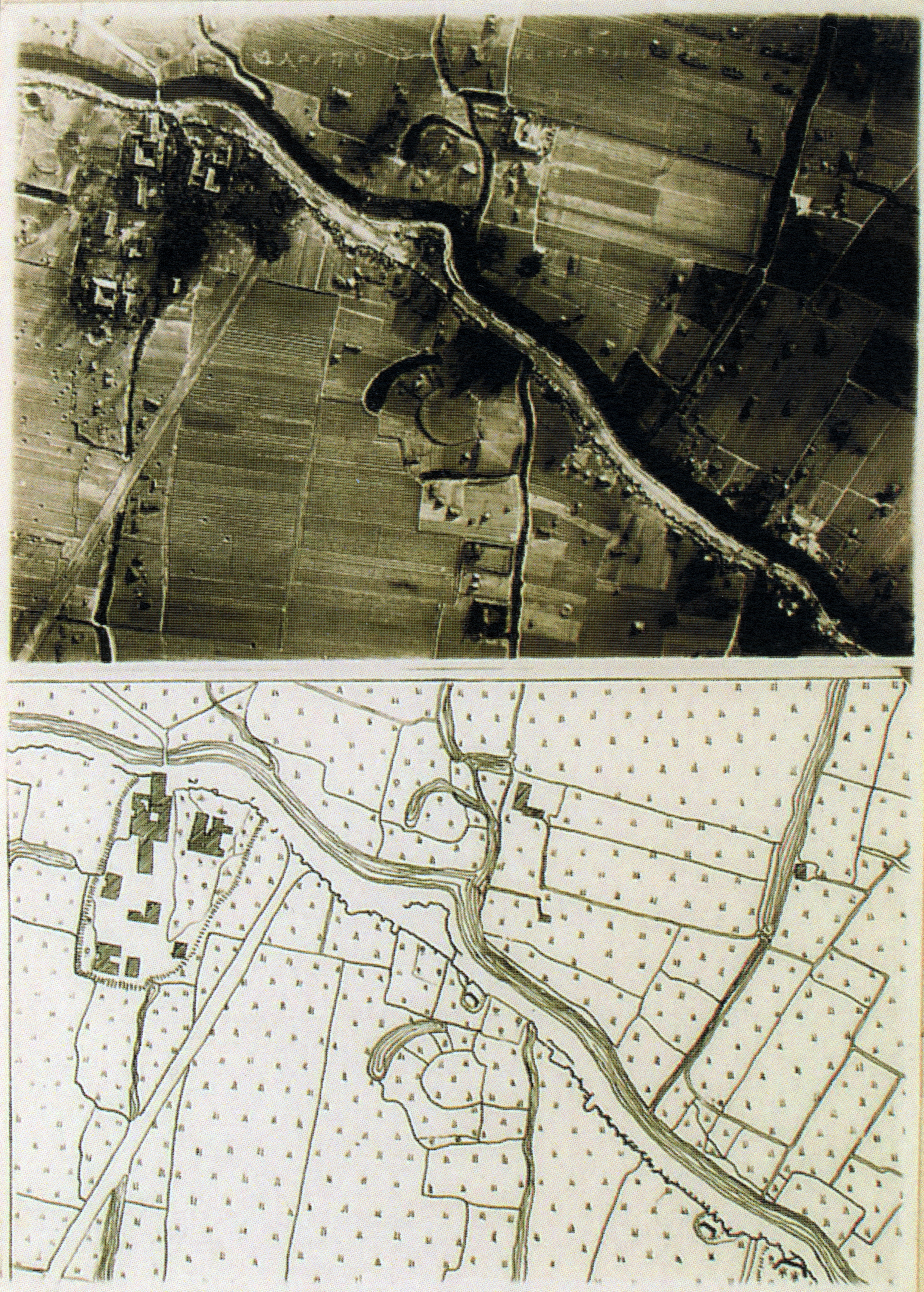
Rationalities suggests that scales are worth analyzing as historical phenomena in their own right. Here, for example, Peter Thilly’s comparison of the spatial logic of Qing regional administration and that of the Jardine-Matheson opium network is instructive. Both coexist in the same locale, the same time and place. Yet both produce very different spatio-temporalities and concepts of scale. Likewise, Sakura Christmas and Michitake Aso show how scale in the history of “aerial zones” is made up of non-overlapping layers of knowledge, history, media, topography, and political networks. Each scale enables or constrains the ability of aerial photographers, in Christmas’s example, or Viet Minh anti-biological warfare activists, in Aso’s example, to achieve their goals. In her analysis of the oral histories of Okinawan migrants to Taiwan, Hiroko Matsuda shows how these “liminal” actors produced their own scalar relationships through a combination of topographical, network, territorial, and market rationalities, even as their physical and social locations were shaped by the scalar politics of metropolitan bureaucrats, sugar capitalists, and other actors. Together, the Bodies and Structures modules show how attention to encounters between and across scales generates grounded and situated analyses that bring the spatiality of “modern East Asian history” to life on as many terms as there are histories.
Conceptual Deep-Maps: “East Asia” in Multivocal Space
Deep-mapping East Asia, or any region, requires taking ownership of our maps by recognizing the inherent multivocality of space and mapping our analyses within that multivocal space and its situated relationships of scale. Bodies and Structures 2.0 shows that such multivocal analysis produces spatial histories that push far beyond the traditional objects of spatial historical analysis. “East Asia” in multivocal space is an East Asia whose imaginative geographies and practices of orientation unfold in everyday objects as much as they manifest in maps, networks, and geopolitical articulations of region and culture. Library and exhibition catalogues, department store magazines, legal documents, medical devices, family albums, oral histories, and temple and community festivals reveal the mutual constitutions of space and place in the everyday and the extraordinary, the mundane and the liminal. In Emily Chapman’s module, Yajima Isao’s photography reveals how Yajima used space, place, and mobility to articulate his senses of masculinity, domesticity, agency, and selfhood. Weiting Guo shows how the inhabitants of the city of Wenzhou oriented their daily lives and senses of self by the city’s waterways. As Guo shows, the water oriented social life along non-overlapping spatialities of topography, geopolitics, lineage networks, imaginative geographies, and market. To write about Wenzhou, then, means to grapple with the multiple, coeval spatial sensibilities that intersect in everyday interactions, generate conflict, and structure social time. Likewise, as Maren Ehlers shows, it is fundamentally impossible to understand the history of smallpox vaccinations in early modern Japan without untangling the spatial structures that governed social relations. At the same time, attention to these structures reveals how important working with the particular territorial rationality of warrior rule was to early public health actors. Kasahara Ryō and other doctors did not merely operate within prevailing spatial structures. They used and adapted status boundaries, territorial jurisdictions, and imaginative geographies of center and periphery to accomplish their vaccination goals—all while contending with the demands of a vaccine/virus that required the presence of specific human bodies in specific places at specific times, even as weather and other environmental conditions threw up challenges to such movement.
In individual modules and through our method of reading across places, Bodies and Structures connects spatial structures to lived histories and specific localities: dialectically, as in a place-space relationship; via juxtapositions within spatial concepts and the space of the site; and analytically, through the tracing of multiple itineraries and routes along which people, things, and ideas circulated. Combining these forms of connection yields new approaches to classic concepts in the history of East Asia. For example, one can read across several modules to observe permutations in the spatial structure often referred to as the Sinosphere. Nathaniel Isaacson suggests how images of real and imagined trains and railroads reveal “a Sinosphere in flux—a hybridized landscape transformed by the presence of western technologies and epistemologies,” in which “the railroad running through the landscape symbolizes an era of change in the Sinosphere from the imperial center of a pax sinica, to one state among many.” Shellen Wu also offers an account of a Sinosphere in flux, as Republican officials sought to reconstitute territorial space via the internalization of global discourses of “the frontier” and the physical and imaginative domestication of Mongolia. Focusing on peddlers and migration, David Ambaras suggests that the Sinosphere continued to operate as a networked space that intersected with and adapted to the new territorial formations of the modern international system in the region. The endurance of the Sinosphere can also be seen in Mitch Aso’s account of North Vietnamese sociopolitical and scientific framings of the threat of biological warfare: while the Cold War radically transformed frameworks of international relations in East Asia, China remained an ideational and political hub for Việt Minh leaders, who “envisioned Vietnam rejoining a recreated Sinosphere world, this time linked not by Confucian culture but by communist party rule.”
The production of modern East Asia as globally networked space can also be seen in our module builders’ work on capital flows and the fixing of commodity exchanges in specific localities and sites. Peter Thilly’s project on the opium trade in 1830s Fujian, with its connection to both the Jardine Matheson network and to Qing lineage, exchange, and administrative systems, offers one window into this process of reconfiguration—one that is perfectly complemented by Tim Yang’s treatment of the displacement of the early modern Japanese patent medicine trade by a new kind of drugstore franchise system predicated on an American-style reorganization of urban public space and individual consumer attitudes. Noriko Aso’s module on Mitsukoshi Department Store, meanwhile, shows how new consumer emporia made themselves at home across the Japanese imperium; the glossy magazines she analyzes resonate with Sakura Christmas’s study of Manchurian Airways’ commodification and strategic appropriation of airspace, which for all its abstractions depended on highly localized exchanges of fuel and diplomatic ritual across the Eurasian landmass.
As it deepens our knowledge of classic concepts in the field, thinking dialectically, by juxtaposition, and through connection generates new sensibilities about what constitutes a key spatial concept in modern East Asian history. Concepts such as “pioneer” take on specific meaning and become sites of action in the context of East Asia’s overlapping colonialisms in modules by Evan N. Dawley, Magdalena Kolodziej, and Shellen X. Wu. Likewise, the spatial figure of “the Corporation” emerges as a significant player in the movement of commodities, the articulation of legal and political boundaries, expertise, and the day-to-day operation of colonial power relations in modules by Peter D. Thilly, Noriko Aso, Sakura Christmas, and Timothy Yang. Mitchitake Aso, Maren Ehlers, and Peter D. Thilly join with historians of science and the environment in identifying “biota” as a foundational actor and site of conflict in East Asian history. Those interested in the ways in which technologies and material objects (re)constitute space and place through their physical operations, social locations, and ideological affordances will find much to think with in the discussions of cameras, transport devices, and buildings that run through the various modules.
It is easy to overlook these concepts as foundational to modern East Asian history because, unlike a concept like “Sinosphere,” whose very morphemes signify “Asia,” terms such as “pioneers,” “corporation,” “biota,” or “camera” do not immediately invoke a specific place. It is easy to say that they circulate within East Asian history but they are not of East Asian history. But, as Bodies and Structures shows, the multivocality of space applies to the conceptual map of historical thinking as well—we need not define a specifically “East Asian” concept of pioneers, corporation, biota, or camera in order to underscore how each has instantiated significant spatial structures and served as a significant site of conflict in the many stories that make up the history of East Asia (Azuma 2019; McLaughlin et al 2021; Onaga 2013).
Conclusion
The digital structure of the site makes it possible to visualize new conceptual and thematic mappings and highlight a dynamic array of juxtaposition. It is also a practice that we hope to see carried out in different forms in more traditionally-structured print formats (see, e.g., Corrigan 2017) and other digital approaches to humanistic inquiry. Above all, we call for scholarship that starts from the three propositions that Doreen Massey articulated many years ago: first, that space is produced relationally, across multiple scales; second, that space is “the sphere…of coexisting heterogeneity”; and third, that space is “always under construction” (2005, 9). We see these propositions as foundational to an ethical scholarship that eschews the absolutisms and limitations of older conceptions of spatial inquiry and of the map itself.
Ethical scholarship requires owning our maps. Bodies and Structures owns its maps by underscoring their incompleteness and their situatedness. Our mappings reflect our own concerns as scholars as well as the history of knowledge production about East Asia, the uneven coverage and colonial categories of archives, and the limits and affordances of our own bodies, family systems, social positions, and institutional and social support networks. Bodies and Structures invites you to join in this process by examining how our mapping of East Asian history reflects, challenges, and expands your own.
References
Ambaras, David R., Curtis Fletcher, Erik Loyer, and Kate McDonald. 2019. “Building a Multivocal Spatial History: Scalar and the Bodies and Structures Project (Part 3),” Platform: a digital forum for conversations about buildings, spaces, and landscapes, August 19, 2019.
Azuma, Eiichirō. 2019. In Search of Our Frontier: Japanese America and Settler Colonialism in the Construction of Japan’s Borderless Empire. Berkeley: University of California Press.
Certeau, Michel de. 1984. The Practice of Everyday Life. Translated by Steven Rendall. Berkeley: University of California Press.
Corrigan, John. 2021. Commentary, “Bodies and Structures: Deep-Mapping Modern East Asian History,” Panel at American Historical Association Annual Meeting 2021 (Virtual). Recorded April 19, 2021. Availabe on YouTube.
——— 2015. “Genealogies of Emplacement.” In Deep Maps and Spatial Narratives, edited by David J. Bodenhamer, John Corrigan, and Trevor M. Harris, 54–71. Bloomington: Indiana University Press.
Corrigan, John, ed. 2017. Religion, Space, and the Atlantic World. Columbia, South Carolina: University of South Carolina Press.
Duara, Prasenjit. 2010. “Asia Redux: Conceptualizing a Region for Our Times.” The Journal of Asian Studies 69, no. 4: 963–83.
Ho, Engseng. 2017. “Inter-Asian Concepts for Mobile Societies.” The Journal of Asian Studies 76, no. 4: 907–28.
Howitt, Richard. 1998. “Scale as Relation: Musical Metaphors of Geographical Scale.” Area 30, no. 1: 49–58.
Lewis, Martin W., and Kären E. Wigen. 1997. The Myth of Continents: A Critique of Metageography. Berkeley: University of California Press.
Massey, Doreen B. 2005. For Space. London; Thousand Oaks, Calif.: SAGE.
McLaughlin, Levi, Aike P. Rots, Jolyn Baraka Thomas, and Chika Watanabe. 2021. “Investigating the Corporate Form in Practice: Heterarchy, hitozukuri, Hello Kitty, and the Public Good.” The Immanent Frame. Published April 2, 2021.
Onaga, Lisa A. 2013. “Bombyx and Bugs in Meiji Japan: Toward a Multispecies History?” Scholar & Feminist Online 11, no. 3. . Accessed May 21, 2021.
Pearson, Mike, and Michael Shanks. 2014. “Pearson|Shanks—Theatre/Archaeology—Return and Prospect.” In Art and Archaeology: Collaborations, Conversations, Criticisms, edited by Ian Alden Russell and Andrew Cochrane, 199–230. One World Archaeology. New York, Heidelberg, Dordrecht, and London: Springer.
Pickles, John. 2012. A History of Spaces: Cartographic Reason, Mapping and the Geo-Coded World. Milton Park, Abingdon, Oxon and New York: Routledge.
Tagliacozzo, Eric, Helen F. Siu, and Peter C Perdue, eds. 2015a. Asia Inside Out: Connected Places. Cambridge, Massachusetts and London: Harvard University Press.
——— 2015b. Asia Inside Out: Changing Times. Cambridge, Massachusetts and London: Harvard University Press.
——— 2019. Asia Inside Out: Itinerant People. Cambridge, Massachusetts and London: Harvard University Press.
Thongchai, Winichakul. 1997. Siam Mapped: A History of the Geo-Body of a Nation. Honolulu: University of Hawai‘i Press.